Our objective today is to go as far south into the approved collection Zone B as we can.
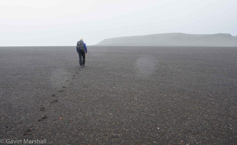 Fred and I left Base Camp at 08:15 and headed south. We had made an agreement to leave cameras untouched until we were across ground we had previously travelled as we knew more photos stops would just slow us down. I’d like to say we stuck to the agreement but NO. By the middle of the Nularbor we were snapping away again.
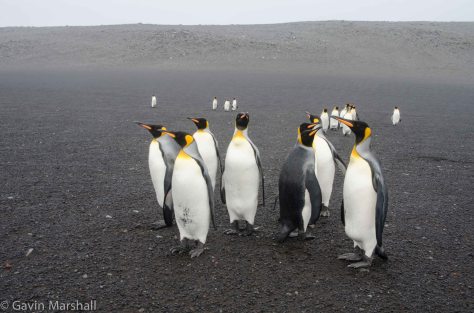 At the base of Mt Andre / Nularbor a small group of King penguins approached us and commenced the usual meet and greet process that we have come to expect from them – more photos.
We continued on south and were soon at the northern end of South West Bay where we stopped to take in the view. The bay stretched out to the south, the wind was coming in from the west, the waves were crashing in on the shore and the misty rain was creating an blurred view of the Kildakelly headlands.
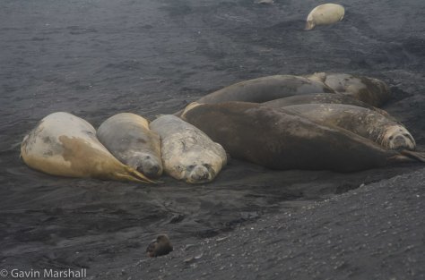 A group of 8 huge male elephant seals that had hauled out onto the beach at the base of Kildakelly Head took our attention and we spent 30 minutes watching and photographing before continuing south. We crossed a small glacial stream and noted several very small fresher water streams that just disappeared into the sand.
 We crossed the Schmidt glacier stream right on the shoreline where it spread out into many small flows and then we continued south to Erratic Point. The surf at this point was whipped by the wind and reasonably rough as it smashed onto the large rocks 10-20 metres of the beach.
We had been observing a greater volume of marine debris on the western beaches and Fred and I completed a count of bottles and other debris items on 100metres of beach at Erratic point area. The results were enough to make me feel physically sick!
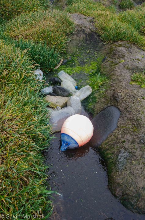 I was surprised how badly this affected me but here we saw the impact on Heard Island from those many 1000’s of kilometres away. The gully was awash with waste. In a 30m stretch we counted –
- 55 600mm – 1.5l plastic drink bottles
- 7 cleaning product plastic bottles
- 1 very large plastic flows (1m circumference approx.)
- 1 large marine float with antenna
- 2 polystyrene floats
- 1 gas cylinder
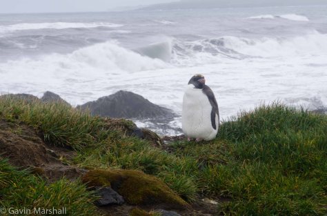 The good news from this location was that we saw out one and only (to date) Macaroni penguin. We came across this little guy as we climbed the ridge (old moraine) out of the gully. He sat all alone on the very edge of the 5m drop down to the beach looking seaward. It was almost as if he were asking “how did I get left behind? Maybe he was sick and unwilling to take the plunge and go to sea?
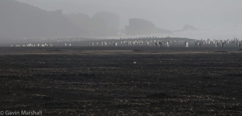
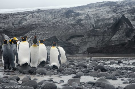
Cresting this ridge brought even more “new” views to comprehend. There was a Gento penguin rookery to our left (inland) approx 100m and 300m approx further south was the Vahsel glacier.
Fred headed directly down to the beach while I took a short detour to the Gento rookery.
Black and white – they were the overriding colours in this landscape. The black of the beach sand and rock and grit of the moraine debris on the ice, the white of the glacier ice. And amongst all this the flashes of gold of the King penguins.
 We turned inland and followed the stream back to the first of the lagoons that we had seen from the ridge. There were King penguins here and they made great photo subjects with the glacier as a backdrop.
Further up the stream we came to the next lagoon with small icebergs floating in it – more photos!
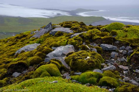
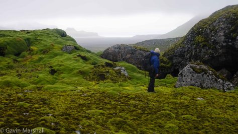 We turned north here and regained the ridgeline , we were in a new world again. Lush green moss, azorella plant that flowed over rocks like a waterfall and Kerguelen Cabbage. It was sensory overload – we had seen and experienced too much since leaving camp.
We were in an area that formed a small basin area – sheltered from the light wind and could see north to Atlas cove and the Braveheart was just visible anchored in the bay.
I convinced Fred that I had to “summit” the small rise approx 50m to the west, once another higher point was in view and off course I continued on. As well as the HUGE views north to Atlas cove I now had a view to the east, a lush green valley with several streams running down it from the Schmidt glacier and at the base of this cliff was a large penguin colony. This was a no brainer – we had to descend and make a detour up this valley.
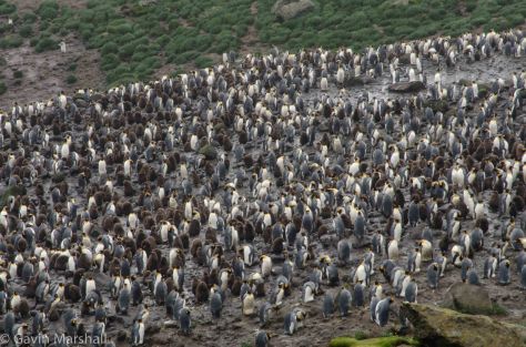 We slipped out way down the northern side of our ridge, crossed a freshwater stream and made a small height gain over kilometre (approx) distance to the penguins. This was a real penguin experience – thousands of king penguins and chicks from this years hatch with their brown down still to shed. And the smell was overpowering.
We spent about an hour watching the penguins before setting off for Base Camp. This required us to return to the West Bay beach to pass the glacial stream, cross the Nularbor and then the final stretch into Base camp.
If you enjoyed this glimpse into Heard Island like my page as I’ve got more stories coming as my Heard Island Expedition continues.
Gavin

 I am 4,000km’s from the nearest populated land mass, below the Antarctic Convergence, and in an area where the ocean drift models suggest that marine debris will not reach. And yet I am observing more plastic bottles, timber, fishing net buoys and other containers than I would expect. And then there is the very valid question – what should I expect?
 I did not expect this “simple data collection activity” to have the emotional impact on me that it had. I was stunned by the first glimpses of the cliff lines of Laurens Peninsula as we first approached Heard Island. Day after day I had new experiences as we moved to different locations on the island.
 It’s feels hard to explain, having returned Sydney, but I now “get” the Tangaroa Blue message. Heard Island has given me a unique view on the significance of this sentence from the Tangoroa Blue web site “if all we do is clean-up, that is all we will ever do“.


 For 4 days I lived in the most remote camp site in the world!
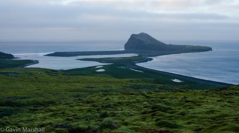 Laurens peninsula is at the northern end of Heard Island and the crew from Braveheart dropped Fred and I into Sydney Cove on the eastern side of the peninsula by zodiac. What an exhilarating ride to a camp site, the swell coupled with the wind made for an rollercoaster ride north from Atlas Bay.
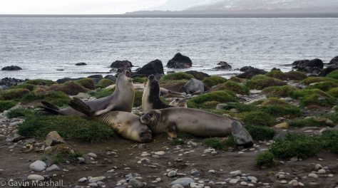 For 3 days we trekked around the hills, the dunes, the moraine left by retreating glaciers and were amazed at the wildlife that we encountered. These birds and animals have never seen a human before and it was interesting to experience how various species accepted or feared our presence. The king penguins, skua and seal pups were trusting while the macaroni and rock hopper penguins had an inbuilt fear factor that prevented them from openly engaging with us.


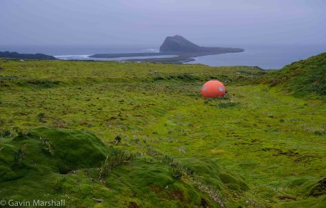
 We left 2 of the light and temperature sensors at the southern end of the bay on the rock finger that reached out to us from Mt Drygalski and then started the short climb. The trick was to pick a line to climb that was clear of the lush green azorella plant and also avoided the small pea to tennis ball sized lava rocks that covered the hillside.
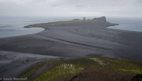 The view along the way is outstanding. North is the Azorella peninsula with Walrus Bay on the left and Corinthian Bay on the right. The unique rock formations of the far north of Azorella peninsula defy my explanation. All I can say is that the bands of different coloured rock that flow upward through the cliff face are impressive and I’m told are part of the Drygalski formation on which Heard Island sits.
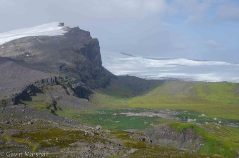 From the summit we headed east along the ridgeline and a view out over the Schmidt glacier and also over the King penguin rookery that we had visited several days before. It’s from here that we really get a view of the trek that these penguins make from the rookery to the sea. We had seen them ambling along when we followed their trail but from above the true magnitude of their trip is clear. Why don’t they move closer to the sea?
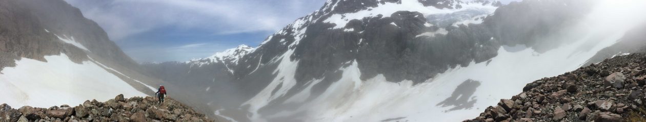
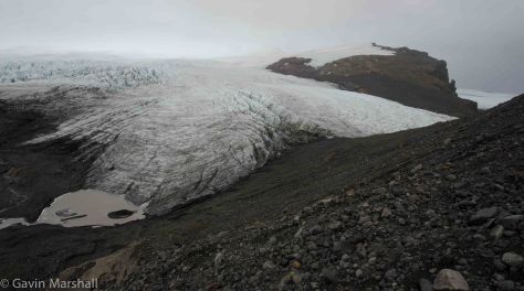 There are ridges of moraine rock in front of us that are just too tempting and I’ve convinced Fred that a walk along the far ridge will give us even better views over the Schmidt glacier. There are several small glacier lagoons that we see from the ridge and maybe on an other trip out this way we can get some time to investigate these.
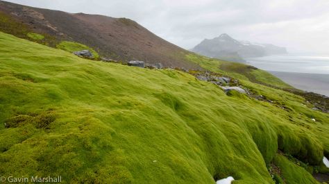 Our route of Mount Drygalski is relatively simple, stay high until we are clear of the cliff lines on the eastern end and then plunge down the lava and sand terraces to reach the sand flats before the short walk back into Base Camp.


 After 4 days on Heard Island I will admit that Heard Island has delivered. From the very first views of the island as we approached on the Braveheart it was patently obvious to me that I had under estimated.
 The waves crash onto the shoreline almost every where you searched for safe passage to the island interior.
 And on that first day I was able to step out for an hour and introduce myself to the local wildlife, and once again I was staggered by the experience. I only had to go to the shoreline 300 metres from our camp to make my first “contact”
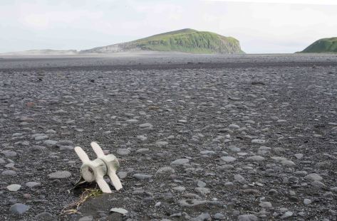
 Birds everywhere and they show no fear of us as we walk along. Skua will fly in at speed directly toward us, or from behind us catching us totally by surprise, and then float on the winds a few metres from us they check us out.


 By the time I arrived the two air beam tents had been erected and were already the subject of much discussion. They needed cleaning that was very obvious but how and by whom? Thankfully the decision was made to engage a commercial cleaning company. Looking back if we had tried to complete the full pressure wash and interior wipe down they completed for us we would never have achieved our planned departure day and time. As it was out team cleaned every metre of Velcro on the tents to make sure that there was no soil, or worse still seeds attached there.
 onto the floor a warehouse floor at Victoria wharf. All of the cases were opened, contents checked and then ordered on the floor in the reverse order required on Heard Island. Everything is to be reverse loaded to the BraveHeart today.
 And this has been going on to with the backdrop of the Cape Towns public Port area. If you live in NZ , think Viaduct area Auckland, if you are in Australia, think Pyrmont Sydney. My first day in the city was on the day of the Argus bike race, the biggest organised bike race in the world. There are so many people in the area.
 So today it’s final preparation, all equipment loads to the Braveheart, we get final details of the immigration requirements that we need to complete tomorrow and then one last walk around the port area that we have come to call “home” for the past 5 days.