
For those that would prefer to take a photo tour of the 3 Passes route over the NZ Southern Alps, heading west from Arthurs Pass village.
Enjoy….

So many waterfalls on the side streams as we headed down the Styx River


Just west of Klondyke corner, on the Waimakariri river – the 3 Passes Route all ahead of us!

Lunch spot on Browning Pass. Not a bad place to take a break

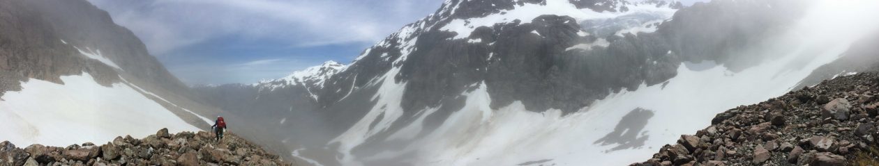
Heading into the mist as we climbed higher to Harman Pass

A typical NZ swing bridge – just a few minutes out from Harman hut.

Rest day wandering on flats above Morpeth Hut

West Coast “sludge”


My favourite – another waterfall, another stream crossing

Looking south from Browning Pass down the Wilberforce River. Morpeth hut is located on the side stream centre of the image

Looking “down” the climb up to Browning Pass.

Carrington HUt

The lush green of a NZ West Coast Bush

There were many waterfalls on th climb up to Harman Pass .


Standing on Browning Pass looking north over Lake Browning


The West Coast track team cut this track as they surveyed a route to me with the team coming West from Canturbury

Blue Ducks on the Styx River


Dropping down to Morpeth Hut with the Marshal range behind

NZ Fantail

The flats and tarns just before dropping down to Morpeth Hut

This is an awesome partnership that we were able to see the benefits of when we came across the family of 9 Blue Duck on the Styx River


End of the day, end of the walk. It’s all over as we wait for a ride back into Hokitika for a cold beer

Just about to start up to Browning Pass. The router is to the left of the image with the exit onto the pass though the scree slope that can be seen in the top left corner.


Heading down into the Cronin Valley from Whitehorn Pass


Heading down from Browning Pass as we head for Harman Hut.


Just starting the climb to Harman Pass.


Eager to get going – first river crossing only 50 metres away from the car park. The first of many to negotiate over the next 5 days.


Lake Browing

A rare sight – Blue Ducks on the Styx River

Surprised, us an them! It was all I could do to get several slightly blurry photos before they were gone.


Moss covered rocks on the walk out along the Styx River

On the “Waimak”, about an hour out from Carrington hut.


After so many stream and river crossings, snow fields and peat bog it is good to abee to take the boots of for the last time!

With Whitehorn Pass in the back the Croning Valley is a rocky route down to valley floor and through to the hut.


