
Arthur’s Pass New Zealand, an inspiring place to go walking !!
Hugh, Bridie and I had 15 days there over the Christmas break to “head for the hills”, assess where our fitness levels were at as Hugh and I prepare for Mt McKinley in May 2017, but importantly just an opportunity to get away from the city and enjoy ourselves.
 We initially set ourselves some reasonably ambitious targets and as has so often been the case when we return to NZ to go walking, the weather made all of the plans irrelevant. We arrived in Arthur’s Pass village on Sunday morning and made ourselves known to the Department of Conservation (DOC) team to find out that all rivers to the northern end of the park were at “extreme flood” levels and were impossible to cross.
A hasty review of the map, a confirmation from Chris, our friendly DOC advisor and we had reorganised ourselves to start at the southern end of the park (Andrews Shelter) and make our way north up the Poulter Valley, climb up ?? to Lake Minchin, turn south and return via the Edwards valley after climbing over Trudge Col.
As it went the plan had merit and looked “do’able.

By day 3 we’d walked up the Poulter valley, spent a night in Poulter Hut and completed the slow climb up the Minchin ?? to Minchin biv. where we took an another overnight before heading back down the valley to Worlsey biv.
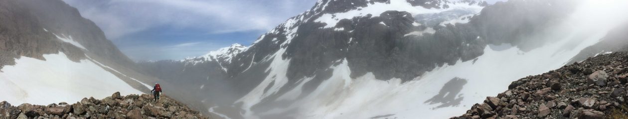
The walking in Arthur’s Pass National Park is fantastic. The Poulter valley is wide and open with big mountain ranges all around. The winding open river makes sure you get your feet wet as numerous side stream and river crossings keep coming at you, and Lake Minchin.

Well it’s just a surprise that awaits you as you come over the ridge and first see it through the beech trees. An amazing blue colour, a reasonable chop on the surface from the wind that’s coming down the valley and a vista that stretches up the valley beyond. It was hard to break ourselves away from the stop we made at the head of the lake to continue on to Minchin biv.

The biv sits up toward the head of the valley about an hours walk from the pass and to access it you need to “boulder hop” and “bush bash” your way there with the stream as a guide. You can see the “Forest Service Orange” painted roof of the biv from the bluffs lower down the valley and you just have to trust yourself that you will eventually come across it as you make your way up stream.
By the end of day four we were back in Worsley biv and suspecting that more bad weather was on the way. The clouds were “close in” and very grey with the wind starting to build. By morning it was raining and a call to DOC for a weather update confirmed the second severe weather warning of our trip. This time, along with the rain, there was snow expected down to 1400 metres.
Rather than take on Trudge Col in this weather it wasn’t a difficult decision to turn and return via Casey Saddle to Andrews shelter, reversing our inward route. But first we had to wait for the rivers to drop as we were on the wrong side of ??? stream
 By late afternoon of day 5 we were back in Arthur’s Pass village, installed at the “Wobbly Kea” enjoying a cold beer and a hot pizza refining our plans for phase 2 of the trip – the 3 Passes walk through to Hokitika.
Heres a gallery of photo’s from this trip in the Poulter Valley.
Please “LIKE” my blog page as there’s more stories coming from the trip to New Zealand – thank you.
Gavin


